
In the early morning of March 23, 2024, crew members aboard a military-contracted supply vessel Unaizah May 4 (UM4) were making their way to a submerged reef in the Spratly Island of the South China Sea for another resupply mission. Second Thomas Shoal, known locally as Ayungin Shoal, lies 105 nautical miles west of Palawan island in the Philippines.
The shoal is home to a small contingent of Filipino marines who have been stationed there since 1999 in a moored, rusting, second world war-era ship, called BRP Sierra Madre. The marines are tasked with guarding the reef which is claimed by both the Philippines and China.
But on the way to the routine rotation and resupply mission to Ayungin Shoal, the crew of UM4 were met with unprovoked aggression and maneuvers of the Chinese Coast Guard. Video released by the Armed Forces of the Philippines shows the supply vessel being fired on by water cannons by two Chinese Coast Guard Ships.
The unprovoked attack from China caused severe damaged to the supply vessel and injuries to at least four Filipino crew members.
Chinese navy and coastguard vessels continue to patrol the Spratly Islands in the West Philippine sea, harassing Filipino troops using military-grade lasers, and now water cannons.
In 2016, the Permanent Court of Arbitration in The Hague ruled in favor of the Philippines in a case against China's territorial claims in the South China Sea. The court found that China's claims to the area were invalid under the United Nations Convention on the Law of the Sea (UNCLOS), which both countries are signatories to. The ruling was a major victory for the Philippines, which had been locked in a territorial dispute with China over the area for years.
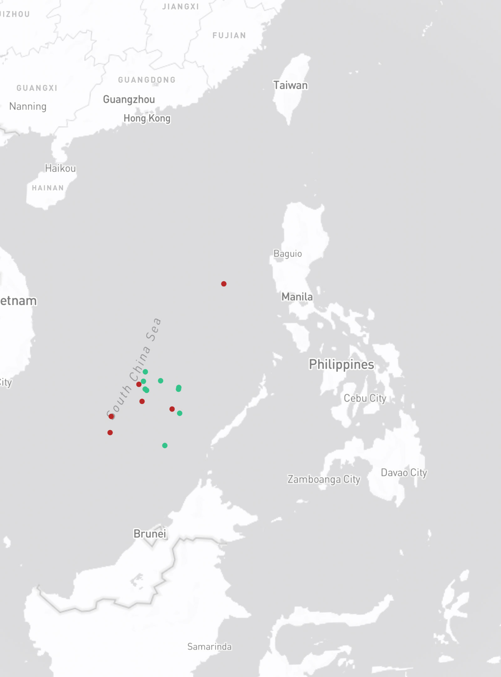
This is a map of the Philipppines. The green dots are the nine natural islands/sandbars/reefs in the Spratlys which the Philippines holds. While the red dots are the islands militarized by China.
This is called the baseline. It is the line along the coast from which the seaward limits of a state's territorial sea and maritime zones of jurisdiction, such as the exclusive economic zone, are measured.
This area shows the exclusive economic zone. It extends 200 nautical miles from the baseline and gives the Philippines exclusive sovereign rights to explore and exploit the natural resources within it.
Meanwhile, this is the nine-dash line used by the Chinese Communist Party to claim all territories in the South China Sea.
In 2016, the international tribunal in The Hague ruled in favor of the Philippines and rejected China's all-encompassing line which it found to lack legal basis.
Despite the ruling, China has continued to militarize the islands in the South China Sea, including those within the Philippines' exclusive economic zone.
The Philippines holds seven natural islands, sandbars, and two reefs in the Spratly Islands this includes Ayungin Shoal. Ayungin Shoal cannot be subject of claim to territorial sovereignty by any state except the Philippines.
Claims to other islands in the Spratlys remain unresolved. While the landmark arbitral ruling has invalidated China's nine-dash line, claims to islands are territorial or sovereignty claims to land that goes beyond the tribunal's jurisdiction. Taiwan and Vietnam are also claiming the whole Spratly Islands, while portions are claimed by Malaysia, and Brunei.
According to maritime law expert Professor Jay Batongbacal, it is possible for the Philippines to lay claim to the seabed around islands outside the EEZ as part of the country's Extended Continental Shelf. While doing so won't affect the sovereignty claim, it does provide a legal basis for claiming the natural resources of the seabed.
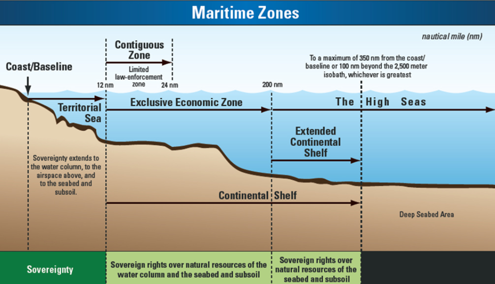
The United Nations Convention on the Law of the Sea (UNCLOS) defines the continental shelf as the part of the seabed over which a coastal State exercises sovereign rights with regard to the exploration and exploitation of natural resources, such as oil, gas deposits, minerals, and other biological resources.
This legal jurisdiction extends up to 200 nautical miles from the coastline, or beyond if the shelf naturally extends farther.
Aside from the illegal presence of Chinese Maritime Militia vessels in the West Philippine Sea, Beijing continues to militarize and build artificial islands in the Spratlys.
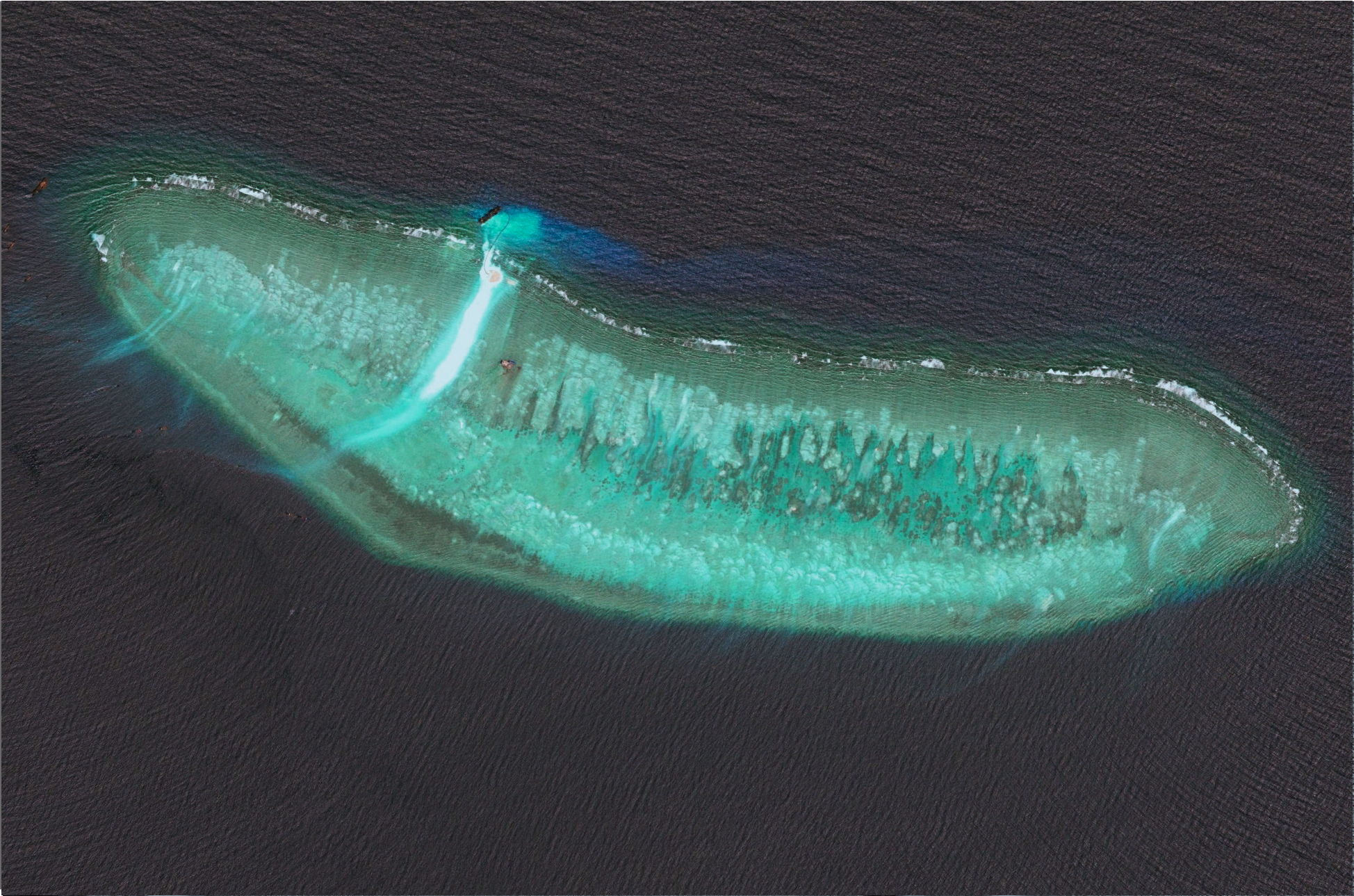
Satellite images from Google Earth Pro taken from 2014 and the present show the military facilities built by China on several reefs in the Spratly Island namely: Cuarteron Reef, Fiery Cross Reef, Gaven Reefs, Mischief Reef, and Subi Reef. China has built military facilities in these strategic areas including airstrips, radar systems, and missile launchers.
Cuarteron Reef known locally as Calderon reef is outside the Philippines' exclusive economic zone but within its continental shelf.
China's artificial island now covers 22.7 hectares of Calderon reef and includes a high-frequency radar which monitors surface and air traffic across the southern portion of the South China Sea.
Fiery Cross Reef known locally as Kagitingan Reef is a submerged feature just outside the Philippines' exclusive economic zone but within its continental shelf.
In 1987, China erected a weather station on Fiery Cross Reef to help UNESCO's global oceanic survey, only to transform it into a military outpost with a 3-kilometer airstrip.
Gaven Reef known locally as Burgos reef is a low-tide elevation located 354 nautical miles west of Palawan. It is just outside the Philippines' exclusive economic zone but within its continental shelf.
China has reclaimed 13.6 hectares of land on Gaven Reef and built a small garrison and a structure that may be an anti-aircraft tower.
Mischief Reef known locally as Panganiban reef is a low-tide elevation within the Philippines' exclusive economic zone. Under UNCLOS, only the Philippines can exploit its natural resources or erect structures.
In 1995, China built octagonal huts on Mischief Reef which it claimed to be shelters for fishermen. Now it is one of the most militarized features in the Spratlys with missile arsenals, aircraft hangars, radar systems and other military facilities.
Subi Reef known locally as Zamora Reef is a low-tide elevation outside of the Philippines' exclusive economic zone but within its extended continental shelf. Under UNCLOS, only the Philippines can erect structures or create artificial islands on this reef.
China seized Subi Reef in 1988 and created a 394-hectare artificial island containing a 3-kilometer airstrip and a seaport.
China's actions in the South China Sea have been met with criticism from the international community. But the underlying consequence of China's militarization of the islands is on the marine environment. A 2023 study by the Asia Maritime Transparency Initiative and the China Ocean Institute shows the ecological damage wrought by island building, giant clam harvesting, and overfishing.
The Philippines has condemned China for its provocative actions against Filipino fishermen and crew members and fought against the militarization of reefs within the exclusive economic zone and the extended continental shelf. However, China refuses to recognize the arbitral win.
After the water cannon incident on March 23, China's Defense Ministry even accused the Philippines of escalating the maritime disputes by undertaking provocative moves and spreading misinformation to mislead the international community.
Below are the coordinates of the five reefs shown in the data project. These coordinates are based on the data from the Asia Maritime Transparency Initiative and the Center for Strategic and International Studies.
The full list of the coordinates of the island features, sandbars, and reefs held by the Philippines, as well as the other island features militarized by China, can be found on this text file saved on the GitHub project.
The baseline coordinates used in the Philippine map are taken from Republic Act 9522 (2009). The maritime zones are from the Flanders Maritime Boundaries database.
This data project was done in consultation with maritime law expert Prof. Jay Batongbacal.
For more information on the South China Sea disputes, you can visit the Asia Maritime Transparency Initiative and the Center for Strategic and International Studies.